Other sites
Ie. not Solar or Lunar
1) Â 'Waymarkers'
A backsight with at least one clear horizon and an  indicated direction but no plausible explanation.  (E.g. remains of a stone circle.)  For these stones the indicated directions appear to be random and in no case is there a usable foresight feature with a key lunar or calendrical declination. Directions ± 10Ⱐof the indicated direction were checked with null result.    There is no certainty that they are (or were) waymarkers, but whatever their purpose they are not backsights for alignments.
a) W1 Mullach Dubh IS12 Â (map ref. 4037 6410)

A somewhat irregular stone block about 1.2m x 0.8 x 0.5m.  It is situated on a slight rise about 1 km. south of Knockleary (IS11) and can be easily seen from many directions. There is no indicated direction and no alignment was found.


b) Â W2 Uisgeantsuidhe IS19 Â (Map ref. 2938 6335)

A large somewhat irregular slab 2.5 x 1.4 x 0.5 m. It is aligned close to North/ South.
There can be be alignment in either direction.  In the south the distant skyline is too low - the moon in that direction would be about 4° above the horizon.  The moon (or sun) could never be in the region indicated to the north.
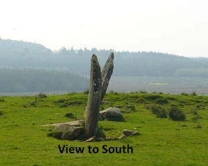
c) Â W3 Gartacharra IS23 Â Â (Map ref. 2527 6137)

A fairly regular slab 2.7 x 0.8 x 0.4 m. aligned close to East/ West and  leaning at about 20° to the south.  The can be no alignment to the west where the featureless ground rises to the nearby horizon. The view to the east is as shown. No alignment was found.
d) W4  Carn Mor  IS24  (Map ref.  2241 6041)
A slab 3.0 x 0.7 x 0.3 m. Â orientated approximately East/ West in a shallow basin with some features to the east. It gives no alignment and so given as a 'waymarker' despite the fact that a typical waymarker is usually more prominently situated.
There is a fallen stone, a 4 m. slab, reported about a km. SE  (IS25, Cnoc Thornasaig, map ref. 2317 6000).  Given that the  two stones discussed above(IS23 & 19) are in the same general region, there is a possibility that these four stones are the remaining stones which marked a route. (It is possible of course that at one time there were more stones.)


e) w5 Kilbride IS42 Â (map ref. 3838 4657)
A regular, possibly shaped, stone 2.5 x 0.9 x 0.4 m. Â No alignment was found.


f) W6 Â Trudernish IS36 Â (map ref. 4630 5290)

A stone 1.8 x 0.6 x 0.35 m. Situated new the shore with a view (ENE) to distant (30 km.) hills on the mainland. No alignment was found.
 2) Trees/ Fallen etc. i.e. no relevant measurements could be made
a)  IS18 Foreland House  Map ref. 2692 6429  (Trees)
b)  IS25 Cnoc Thornasaig  Map ref. 2317 6000 (Fallen)
c) IS26 Droighneach  Map ref. 2106 5938 (Trees)
d)  IS38 Cnoc Rhaonastil  Map ref. 4369 4832 (Trees)
e) IS39 Lagavulin North  Map ref. 3954 4621 (Trees)
f)  IS47 Kintra  Map ref. 3283 4781 (Trees)
3) Probably not Prehistoric  (M on map for 'Medieval'.)
IS4 Finlaggan (Map ref. 3927 6856).  This stone (2.0 x 1.3 x 0.6 m.) is very regular and probably shaped. It gives no alignment and  is probably associated with the nearby  ruins which were the headquarters of the 'Lords of the Isles' dating from about 1300 AD.


4) Â Three stone row (marked 3)
IS41 Laphroig  (Map ref. 3895 4607). A fine 3 stone row, 6 m. long and orientated close to North/ South. The end stones are both about 2.5 - 3 m. tall. The central one (fallen) is of similar size.  The horizon to the  south  is low and the southern major standstill moon would have been some 4° above it. The moon could never have been as far north as the opposite direction, and in any case there is a nearby large rock outcrop in that direction. Such North/ South orientations without alignments are not uncommon but must have served a purpose.

5) Â Stone circle at Cultoon
IS 28 Map ref. 1956 5697. Â Excavated by Euan MacKie in 1974/5
Although stone circles are not generally considered in this blog, Cultoon is relvant as there is a possibility of an alignment. Namely the long axis of the elliptical circle indicating a hill in the SW on Northern Ireland some 40 km. distant for the winter solstice setting sun.
This entry will be continued when a suitable photograph of the relevant feature(s) is obtained.