Stones with no alignment e.g. Waymarkers, Indicators etc.
The sites from north to south are:
- #4 Benderloch North NM 9062 3865 Thom - , Ruggles LN7
- #6 Barcaldine Castle Farm, NM 912 402 Thom - , Ruggles -
- #8 Ledaig South, NM 9033 3802 Thom M8/3, Ruggles LN8
- #9 Taynuilt NN 0120 3115 Thom - , Ruggles LN14
- #14 Strontoiller (Loch Nell) NM 9080 2893 Thom A1/2, Ruggles LN17
- #17 Craigantairbh NM 8595 0157 Thom A2/23, Ruggles AR9
- #33 Upper Fernoch NR 7280 8614 Thom - , Ruggles AR38
1) #4 Benderloch North NM 9062 3865 Thom - , Ruggles LN7
A stone about 1.6m x 1.0m x o.3m with a similar sized stone leaning against it and orientated approximately NW/ SE. It seemed possible that it could be a broken stone (but see later).

Horizons in both directions (NW and SE) were checked with a null result. (Note: Because of the view to the NW was partly obstructed by buildings measurements were made from 35m back and reduced to the normal OP.)


Note: It seems probable that the stones are the remains of a stone circle. Ruggles in BAR 123 (1984) '300 western Scottish sites gives:-

2) #6 Barcaldine Castle Farm NM 912 402 Thom - , Ruggles -
The pencil like stone ( 2.1m x 0.45m x 0.2m) is on a low hilltop.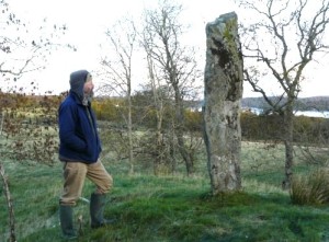
It has been moved from its original position:- From the archive of The Royal Commission of Ancient and Historic Monuments (Scotland):-
Archaeological Notes
NM94SW 3 9117 4027.
(NM 9117 4027) Standing Stone (NR)
This standing stone formerly stood about 3.1 metres from the most westerly of the three cairns described under NM94SW 10. When it fell, it was re-erected on its present site (Smith 1879). As it now stands, it measures 0.45 by 0.15 metres at its base and stands 2.1 metres in height.
RCAHMS 1975.
As described.
Surveyed at 1:2500 scale
Visited by OS (RD) 9 November 1971.
There were clear views to the north east. this was measured for the purposes of the chance alignments assessment. No alignments were found.
3) #8 Ledaig South NM 9033 3802 Thom M8/3 , Ruggles LN8
Ruggles in 300 western Scottish sites has :-


There is one rough conglomerate block. No others were found.

(4) #9 Taynuilt NN 0120 3115 Thom - , Ruggles LN14
As reported by Ruggles:- A squat standing stone 1.2m tall which appears originally to have been taller. It is roughly triangular in cross section.
 There is limited horizon suitable for alignments. None was found (See in 'Random Sites')
The stone is situated in open ground near the top of a bank

(5) #14 Strontoiller (Loch Nell) NM 9080 2893 Thom A1/2, Ruggles LN17
A large square block of conglomerate about 3.4m x 1.2m x 1.2m with a smaller dome shaped stone about 1.3m high and about 50m to the SE which might be genuine. The line of the stones to the NW is clear of trees but otherwise nearby and hillside trees obscure any possible alignment. (For example in the opposite direction.) The line of the stones to the NW is close to 306°. Alignment for the sun (Thom epoch 3, MSB pp.113/114) could be indicated.


There is a stone circle + a kerb-cairn in the area. See Thom (SRSS 1990, BAR 560(i)) where there is also given a possible solar alignment to the SE.
The site was partially surveyed by Bailey and Cooke, concluding that no alignments were found. (Nature Vol.253 February 6 1975, pp431-2)
(6) #17 Craigantairbh NM 8595 0157 Thom A2/23, Ruggles AR9
This was a very large stone some 5m tall. However the upper 2/3 was broken off in a gale in 1879. The lower part although leaning slightly is firmly set in its stone hole. It is aligned approximately 75°/255° ± 4°
 To the ENE the horizon lacks features. To the WSW there is a steep nearby hillside with a wood on the horizon. This direction is indicated by the stump.
Thom in SRSS Vol 1 p123 has:-

Measurements showed that the direction was consistent with the ‘Bronze Age Equinox’ i.e. half way between the solstices by time, which gives about +0°.5 declination.The hidden hillside was visited. No obvious features were found but inevitably the angle of viewing was not the same as from the stone. The bumps and hollows would appear different.
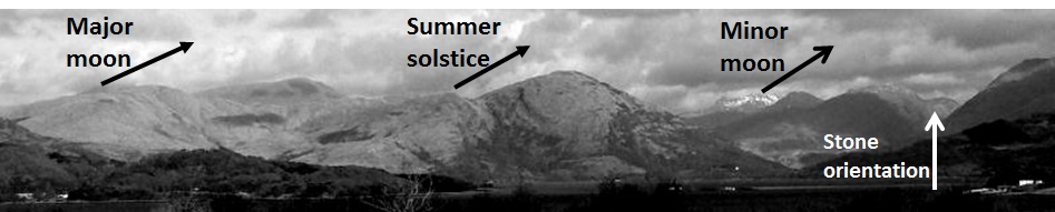
(7) #33 Upper Fernoch Thom - , Ruggles: AR 38 NR7280 8614
This stone has been fully discussed earlier

Measurements showed that there is no alignment. The region of setting southern moon was examined for hidden rock outcrops. None was found. Experience shows that this slender stone is not typical of the stones used to mark lunar backsites. As Thom observed, lunar stones tend to be much more substantial. They give every appearance of importance.


As stated before it is believed that the Upper Fernoch stone serves as an indicator for the 'hidden' (i.e. out of sight) cup marked stone which lies some 300m beyond the hilltop indicated.